- Hietala S., Moilanen J. (2004) Keurusselkа - A New Impact Structure in Central Finland // Journal Tahdet ja avaruus.
- Spray J.G. (2005). Impact Structures listed by Name. Current total number of confirmed impact structures: 172 .
- Dayioglu S., Pesonen L.J., Salminen J., Dypvik H. (2006). A new search strategy for detecting impact structures - examples from Fennoscandia // 40 ESLAB Symposium: 1 International Conference on Impact Cratering in the Solar System, Noordwijk, 8-12 May, 2006, Noordwijk: ESA, P. 57
- Osinski G.R. (2006). The geological record of meteorite impacts // 40th ESLAB First International Conference on Impact Cratering in the Solar System, 8-12 May 2006., Noordwijk,The Netherlands
- Ruotsalainen H.E., Hietala S., Poutanen M., Moilanen J., Pesonen L.J. (2006). Gravity survey of the Keurusselka meteorite impact structure // Bull. Geol. Soc. Finl., P. 134
- Moilanen J. (2009). Impact Structures of the World.
- Pesonen L.J., Mertanen S., Sangchan P., Koljonen E. (editors) (2012). Supercontinent Symposium 2012 - Pre-Excursion Guidebook // Geological Survey of Finland, Espoo, Finland, 100 p.
- Raiskila S., Plado J., Ruotsalainen H., Pesonen L.J. (2013). Geophysical signatures of the Keurusselka meteorite impact structure - implications for crater dimensions // Geophysica, Vol.49, No.1, P. 3-23

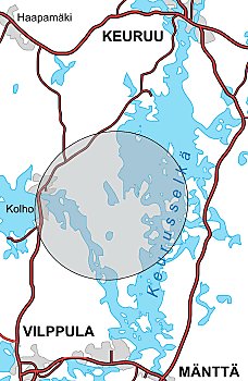
a grey circle is representing an area where shatter cones has found (on the shore of lake Keurusselka)
(Hietala, Moilanen, 2004).

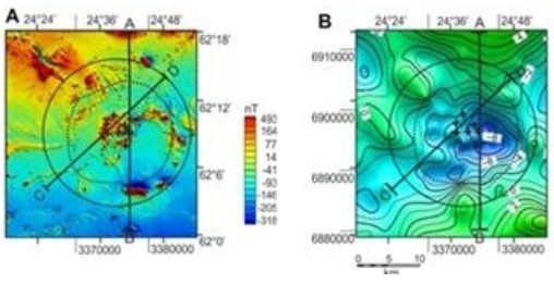
(A) Aeromagnetic map (courtesy of GTK). Shatter cones are marked as crosses. (B) Local Bouguer gravity map (courtesy of FGI).
(Pesonen et al., 2012).
Обзор статей (из РЖ ВИНИТИ "Геология и геофизика"):
Новый подход к проблеме поиска ударных кратеров в Фенноскандии, где по теоретическим оценкам было несколько падений тел крупных (D>60 км) и средних размеров (D=20-60 км). Предлагается объединить усилия исследователей различных направлений, разработать математические алгоритмы для автоматической идентификации кольцевых структур по геофизическим, топографическим и батиметрическим данным и найти новые критерии диагностики ударных эффектов для тех случаев, когда классические критерии ударов уничтожены эрозией или деформациями. Сообщается об обнаружении на территории Финляндии трех новых ударных структур (Сувасвеси, Саариярви, Кеурусселкья) и одной - в Норвегии
(Dayioglu, Pesonen, Salminen, Dypvik, 2006)
Ударная структура Кеурусселкя (Keurusselka) открыта в 2004 г. геологом-любителем в Ц. Финляндии (Hietala S., Moilanen J.). В 2005 г. Финский геодезический институт измерил 4 профиля силы тяжести поперек области кратера с минимальным расстоянием между пунктами измерений 1-2 км. Центр. гравитационного минимума расположен к востоку от площади распространения конусов сотрясений. Локальный минимум остаточной силы тяжести в редукции Бугэ составил =8.5 мГал. Локальные максимумы остаточной силы тяжести вне большой области аномалии: =3,5 и =4,5 мГал. Диаметр остаточного минимума (оценка): ~22-28 км
(Ruotsalainen, Hietala, Poutanen, Moilanen, Pesonen, 2006).
Terrestrial impact structures carry the effects of shock and impact-related processes on targetrocks and minerals. Integration of petrophysical data obtained from surface and drill core rocks with geophysical field studies allows the crater dimensions to be delineated, even when the impact structure is deeply eroded. Our study concentrates on the Mesoproterozoic Keurusselka impact structure, with paleomagnetic and geochemical ({40}Ar/{39}Ar) ages of 1120 and 1140 Ma, respectively; and, especially, its central uplift region, which is characterized by the presence of well-defined in-situ shatter cones. The structure is located within the 1900 - 1860 Ma old granitic Svecofennian domain in central Finland and is deeply eroded. Prominent high-amplitude low-wavelength magnetic anomalies occupy the central uplift region of the structure and are attributed to magnetization caused by a meteorite impact. Corresponding negative gravity anomalies are less distinctive, but are consistent with the magnetic ones. In this paper we present the potential field maps and a geophysical model for the Keurusselka impact structure. Crater dimensions are are estimated from theoretical equations combined with the modeling results. We propose that the original rim-to-rim diameter of Keurusselka structure has been 24 - 27 km
(Raiskila, Plado, Ruotsalainen, Pesonen, 2013).
На главную

